This spring break, the sky was the limit!
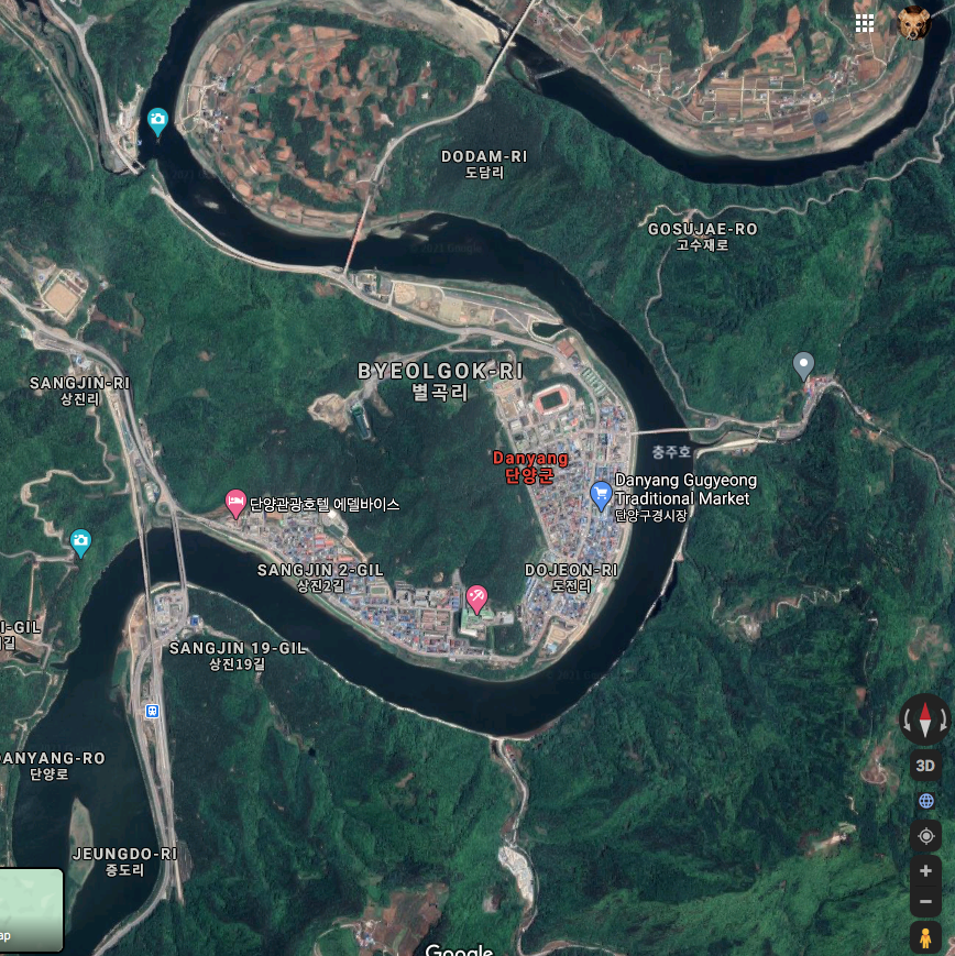
We packed our bags and headed to Danyang, about a 3 1/2 hour drive up the east coast. The modern town of Danyang was develped in 1985; just like Randolph, KS, the old town was submerged when they created nearby Chungju Lake. The town is nestled along the horseshoe that the river creates, so it feels like the mountains totally surround it with the river flowing right through the middle. I took this off of Google maps so you can see the shape of the river and where the city is located.
The mascot of Danyang consists of this man called Ondal, who was a jester in the imperial court. He won the heart of Princess Pyeonggang, breaking through the Korean caste system and eventually becoming a respected general.


first destination: not the sky, but the opposite- Gosu-donggul
고소 동궅


Daisy and Daddy almost fell into a deep chasm filled with bats,

and Daisy had to fight off a bat that tried to steal her purse.


Gosudonggul Cave was created when limestone was deposited about 450 million years ago under shallow sea water near the equator. It was uplifted and moved north {not sure how that happens??}, creating this cave a few tens of millions of years ago. Gosu means 'field of tall reeds' because the area was at some point long ago, filled with fields of tall grasses. When it was discovered in the 1970s, prehistoric stone tools were excavated from the entrance.

The cave is 1395m long, but only 940m is allowed for visitors. For some reason we could not take pictures inside the cave. Eli had anxiety when I snuck out my phone to snap this picture.
 We walked along the platform, going up and down and around stairs.

The cave is multi-level with a stream flowing at the lowest level. Caves tend to have an average temperature year round, regardless of the outside extreme temperatures. This one averages 15º celsius (59º F).

There are a plethora of formations, including soda straws, stalactites, stalagmites, columns, cave corals, flowstone, curtains and helictites. I don't even know what most of those are, but apparently they were all in there. It was fascinating to look at. I snagged a couple pictures off the internet since I wasn't allowed to take them myself.

Most of the time I still feel like I'm in my twenties. But sometimes I am reminded that I am old, like when I was trying to take our picture that had both cave and people in it.


Daisy got frustrated and grabbed the phone and effortlessly snapped a nicely centered selfie.

While we were standing there someone noticed a bat hanging off the ceiling above our heads. Forty-six species of animals reside in Gosu Cave; I don't know what the other 45 are, but we know for sure that bats are one. 


next destination: the Mancheonha Skywalk
만천하 스카이워크


JK. We tried but they were not open. We went looking for the Jando Trail, and thought we found it at the bottom of the hill. We quickly discovered it was not the well-acclaimed Jando Trail, but an outdoor education center called Yaoegyoyungjang.

 'Dodam' is the deep pond among the river surrounding the three peaks. 'Sam' means three and 'bong' means peak; hence the name dodam sambong. One of the leading founders of the Joseon Dynasty grew up here and loved the area so much he went by the pen name Sambong. The little pavilion was originally built in the Joeseon dynasty and restored in 1976.
 next destination: Stone Gate


next destination: Dodamsambong Peaks
도담삼봉

These three peaks are located in the Namhangang River, which the borders the city on three sides. Legend says the peaks represent an angry wife turning away from her husband who has taken a concubine to produce a male heir. The big rock in the middle is called Janggunbong (Husband Rock). The rock on the left which appears to be boasting her pregnant tummy is called Cheopbong (Mistress Rock), and the rock on the right side turning away from the husband in her anger is called the Cheobong (Wife Rock). The heavens, when looking down upon this domestic mess, turned them all to stone.


I was wondering how they built the pavilion on the little island with no land; I found a very old picture way before the dam was built, and there used to be a bit of land surrounding it. Many artists have been commissioned to paint here over the centuries. Here is a picture from the 1700s.


석문 From Dodamsambong you can see a pavillion on the mountain and a large rock not far from it. I could only convince Abe to climb the steps to the pavillion with me to check it out.


From the Ihayangjeong Pavillion you can see two of the three peaks down there.


From there is was just a short hike to Seokmun, or Stone Gate. It is a natural stone formation that they say is the shape of a gate. It was created when a cave collapsed, leaving the largest of its kind is Asia. Mother Mago lived in a cave below the arch; she descended from heaven to fetch water and chose not to return after searching for her binyeo (traditional Korean hairpin), according to a local legend. She was so impressed with the views while searching that she chose to stay as an ordinary peasant, growing crops and expanding farmlands.

 Eli didn't want to do it, and since Abe paraglided years ago on a scout trip he sat out with Eli.

next destination: paragliding

WoW! So. Much. Fun.
Paragliding has been on my list of things to do for the last 30 years or so. I finally did it and it did not disappoint! First we suited up. 


{Thanks for taking one for the team, Pops.}


 Danyang is well known for its eight scenic views along the river. The aquarium had miniature displays of each of them. We spotted the Dodamsambong Peaks.


 This area was designed to write a note and post it on the wall.
 Daisy left this.


At this point the three of us were just a little nervous, especially the Daiser. 

We did a tandem glide, so I wasn't worried about the kids doing it wrong and dying. They told us to run! run! run! until they said stop. So that's what we did. 


Daisy was the most afraid and she makes me laugh when she is scared, so we bought the GoPro video for her. She was terrified before they started but calmed down right away, so we didn't get to see her panic on the video. That's the winding Namhamgang River below from Daisy's point of view.

I am the blue chute back there in the distance. Zeke is the red chute in the background. This picture totally looks photoshopped, but it's the real deal.


They were going down for the landing.

Daisy and I landed first, and that's Zekers coming in behind us.


👇 We started from up there.


I wanted a picture after they drove us back up to the top.  The guy who went tandem with me saw Abe taking our picture. He was super nice and took lots of pictures with the whole family. As I mentioned in another post, the Koreans know how to take pictures and they always suggest poses. I've learned to roll with it because it always turns out cute.

 For the record, I have my jacket on underneath that suit with things in the pockets; that is not my actual Santa-sized tummy poking out.


next destination: Danyang Danuri Aquarium
다누리 아쿠아리웅

The pickup and drop off point for paragliding was right outside the aquarium, so we decided to check it out when we got dropped off. 

The Danuri Aquarium just happens to be the biggest freshwater aquarium in Korea. There are over 145 species of freshwater-only fish, totaling 15,000 fish in 915 tons of water.


See those two love birds peeking through the holes?😜


Abe and Tricia sitting in a tree. K-I-S-S-I-N-G


There was a small area with chipmonks, turtles and otters.

next destination: Mancheonha Skywalk, 2.0
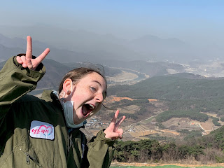
만천하 스카이워크 You can see the skywalk up on the mountain from the road. It sits about 90m above the Namhangang River.
 Here she is, in her full glory. It is 30m high.

 The views were 360º, but I can't really tell you which direction I was looking. This is the east, I think.
 Looking north toward the town.
 Kind of southeast.


The spiral path leads you to the observation deck.


Looking down. That direction I nailed.
 The kids and I opted to take the zip line down to the bottom.
There were two zip lines totaling 980m for both.


There were a lot of activities crammed into that one little area. Here's the layout of the land from the viewpoint of the first zip stop:

Our last activity was the alpine slide. The rails on the left are going up, and the smaller twisty rail on the right is going down. It went fast!


next destination: downtown Danyang
단양
We meandered through the Danyang Market downtown while waiting on our pizza. Lots of traditional Korean foods here. (Notice we were waiting on pizza.)

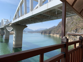
This is the Gosudaegyo Bridge, which you see from downtown.

Our hotel happened to be across the street from City Park, so Abe and I took a couple walks to check out the sights.


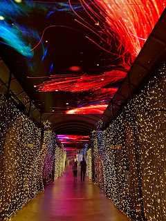
next destination: Suyanggae Light Tunnel
수양걔벛터널 The Suyanggae Light Tunnel is located right outside the Suyanggae Prehistory Museum. A ticket gets you into the little museum as well as the light tunnel.


When the lake was being constructed in 1983, relics from the stone age were discovered. Earthenware, stoneware, and ironware were excavated, as well as the remains of houses including grains inside them. My family practically ran through the museum, but I stopped Eli long enough to get a picture.

One minute you're in the Paleolithic era, and in the blink of an eye you're in a 70s discotheque.

The Suyanggae Light Tunnel was originally a train tunnel that was constructed during the Japanese occupation.


After setting dormant for many years, in 2017 it was converted to a 650-foot long light tunnel. It is South Korea's first multimedia tunnel, complete with tons of LEDs, video, flashing lights and thumping music. Well done with repurposing, Danyang!


 Once we danced our way through the disco party, we continued through to the outside light garden.


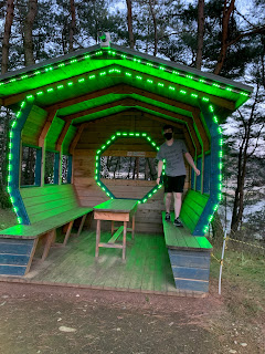


All three of them crammed into this little igloo.


Remember that this is right outside the prehistoric museum, right? Sprinkled amongst these pretty, colorful, modern lights are rando cavemen building fires and stuff. 😜


Look how precious this little boy is.

Even though I have a crush on this big boy, but he's not as quite cute sitting under the lights as that little guy was.

 next destination: Dangyanggang Jando Trail


단양강 잔도

The Dangyanggang Jando Trail is a path built along the small cliffs of the Namhangang River. I read different info and none agreed on the length. The trail is somewhere between 1.2km and 20km long. Abe and I walked along part of it near the hotel, and DanFam5 started at the opposite end; I have no idea how far it is from the starting point to the hotel, but it seems longer than 1.2km. Regardless of the actual length, we did not walk the whole way. Here is the beginning of the trail.

This is looking down the river, away from the trail.


This is looking up the river, toward town.


You can see the sky walk up on top, and that's the Namhangang River Iron Bridge.


At some places you can look through the to the water. 


We walked just a bit past the bridge and turned around so we could hit the road to go home. This journey of our spring break trip was finished.

next destination: Deluxe Apartment in the Sky

[March 29-31]

No comments:
Post a Comment