A ferry ride, a trail through the woods, scaling cliffs that require a rope to get up, suspension bridges over craggy drop-offs, steep stairs, balancing the ridge while grabbing a railing, 360º views of the 할려해상 Hallyeohaesang National Marine Park from the top of the ridgeline.
Sign me up!
My friend told me that 사량도 Saryangdo is her favorite hike here in Korea. When she invited me to join them for a hike I jumped at the opportunity. Saryangdo is located in the westernmost waters of Tongyeong City, just about 45 minutes east of Sacheon. It is actually two islands; one was called 상박도 Sangbakdo Island and the other 하박도 Habakdo Island. The waterway flowing between the two formed a winding shape like a snake, and this strait was called Saryang, eventually becoming the name of the island on the north. Of course there is a legend involved, as is the case with any good Korean land mark. The story is about a man that died of lovesickness because he could not achieve his love and he became a snake.
We started our adventure shortly after the kids left for school. We almost missed the ferry, but slid in just in time.

Catching the first glimpse of the island, we spotted the suspension bridges. If you zoom in you can see the bridge on the little hump in the center. A nickname for the trek is the Jagged Ridge Hike. There are several different peaks on 불모산 Bulmosan Mountain, starting on the east with 옥녀봉 Oknyeobong Peak and finishing with 지리 Jiri Mountain.


When our ferry landed we caught a taxi to the east side of Saryangdo and worked our way all the way across the top. This was the first time we turned around to look back at where we started, in the city below. 사량도댁요 Saryangdodaegyo Bridge is in the background. I took several photos of the bridge from different viewpoints along the hike because it was so pretty.

Some parts of the trail had steps.


Some parts of the trail had rocks.
 This was the first 'WOW!' moment, when we climbed to this little peak.


This is looking east, with Tongyeong in the mountains way back there.


Better bridge view.


We had been working our way through some trees and suddenly this view opened up. It was more amazing in person than the photo shows.


When I turned around backwards (east) the bridge was still in view.


See those stairs? That can be intimidating when you know that you not only have to climb all of them in your near future, but first you have to get there.


Here's a close-up.


Honey badger don't care!


We made it to the bottom of those stairs. They were pretty steep. It cracked me up that there we bunny turds on the steps. I think it's funny that the rabbits choose to use the steps instead of the rocks.


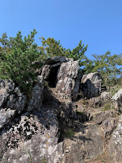
This is peeking around the corner of the big boulder at the top of the stairs.


Here is one of the ropes that I mentioned earlier.


You always see ribbons tied to trees from different groups when hiking.


Oknyeobong Peak is the center of the island. It is 281 meters above sea level. A sign at this point says that there is a legend concerning this peak that "strictly warns of the prohibition and corrupt instincts of incest." Interesting message...I couldn't find anything else on the internet that gave more detail about this and why they felt the need to warn us of this.
 |
| me and Alyxis |
As soon as we made it to the first peak, the next big goal was in sight: the suspension bridges.

Same bridges, zoomed in.


Look at all of those fishing nets in the water.


We would walk through trees for a bit, then up rocks for a bit.


And then up stairs for a bit.


We passed 대항 Daehang Beach on the taxi ride driving from the ferry to our starting point. Once we got on the mountain we spotted it again from above. I took several pictures from different spots along the ridge.


I have a lot of the same pictures, but from different places along the mountain. The views were so amazing, and they kept getting better and better the higher we hiked.


More ropes to grab on to help you get up.


Notice what a steep grade that rock is.


Such a bright pop of color amidst the rocks.


We were getting nearer the bridges.


This hike was not full of flowers like many others, but there were a few.


The steep rock on the right gives you a visual.


We made it to the suspension bridges. Before these bad boys were put in it must have been quite a climb! The amazing thing about mountains here is that tax dollars go into maintaining them, i.e. the ropes, the stairs, and the bridges, etc., yet the hikes are free. Love that.


Looking to the west. The next big goal was that peak on the right.
 Looking back to the east.


These steps were so steep it was pretty much like a ladder.


Notice the bridges we just crossed on the left.


I zoomed in so you can see them better.


At this point there was a sign that said the elderly and the mentally and physically vulnerable should take the detour around instead of going up and over. Of course we went up and over, despite some questions regarding our mentally vulnerable condition; that's a gray area. 😜 After we were home and I was looking up info, I read on three different blogs that many people are injured and there are even a few deaths from careless hikers (often taking selfies). One person said the rescue helicopter flew over them during their hike, and apparently this is a fairly common occurrence according to the locals. Interestingly enough, it was at this point as I was taking a picture of my three friends taking in the view on the hike when I thought how many more safety features would be installed in the US because it looked pretty easy to just roll off this mountainside.

Can you see the bridges at the peak? We walked along that rocky path leading across the middle.


가막봉 Gamabong Peak, which was next, sets at 303m.


The next goal was that peak.


When I zoom in you can see some stairs in the middle of the picture.

There were some spots that were not steep that gave us a little break.

We made it to those stairs.


I zoomed in so you can see more stairs better.


So this sign was posted. We casually walked by like it said welcome.


We made it to the magnum opus! This was the skinny part of the ridge where the view is 360º .


This strip is called 달바위 Dalbawi, or Moon Rock.

The highest peak sets at 400 meters. We crossed the jagged rocks like little mountain goats. Except we hung on to the hand rails just to make sure we didn't fall.


It's pretty breathtaking from up here. What an amazing feeling of being up on the mountain surrounded by the blue water below and purple mountains in the distance, with not much land under your feet.


Yes, that's me panting in the background of the video. In my defense, it was a tough little climb to get here.


This is the view to the east, with Namhae in the far background.

After going down a bit we came to a fork where four trails meet up. On weekends there is a man who carries up water and beer to sell. Apparently it is a little more expensive, but you know, HE CARRIED IT UP THE MOUNTAIN.

One path leads to Jirisan Mountain. That can be a little confusing because there is the 'real' Jirisan Mountain on the mainland. This one used to be called Jiimangsan, meaning Little Jirisan, but over time it has been shortened to Jirisan.

The trip down was over large rocks and a very wooded path. Not breathtaking like the ridge, but peaceful and beautiful in its own right.


"An island with fantastic hiking where the sea and the mountains harmonize."
That is what one description read. I can't argue.
The hike itself was really not that difficult. It wasn't very high as far as mountains go, and our total distance was only 3.5 miles.
But those views.
Plus there was some bad assery going on as I scaled the dangerous cliffs, hanging on to ropes and railings like my life depended on it, 'cuz it kinda did.

[October 1]

No comments:
Post a Comment