This was not our first Chuseok rodeo. Chuseok is basically Thanksgiving. It looked a bit different this year since we can't travel abroad. But I found a trip to Mysterious Ulleungdo Island and decided to go for it.
We started by driving to the east coast to Pohang, which is the main seaport in the Daegu-Gyeongbuk region.
This is the view from our hotel. Nice, huh?
Fall is in the air. It's that perfect temperature where you might be chilly, but then the sun shines and you feel great. Just when you think you might be getting hot, a cool breeze comes along and you feel great again. Not perfect weather for swimming, though. Eli was the first one in and he said it was cold. Not that I had any intention of getting in, but when Eli says it's cold, it's cold.
Abe: My chest is tingling and my legs are numb.

I think pink is his color.
We got a chuckle at the bath towel provided.
The Koreans do not waste time with bath towels like we do. They use little hand towels. This was a disposable one so it was a little longer than most.Our hotel was not too far from Homigot Sunrise Square
호미곶 해맞이광장, which is the most eastern tip of Korea. Some describe the Korean Peninsula as a tiger, and this area is considered the tail, or the hamigot. High five for the tiger tail!
Homigot Sunrise Square is also home to Sangsaeng's Hands, otherwise known as the Hands Of Harmony. One bronze hand is on the shore, and the other is in the East Sea. The two hands together give the message that all people are to live together helping one another like Sangsaeng, symbolizing harmony and coexistence. An English translation of Sangsaeng is 'win-win.'

Every picture I have seen of the hand in the water has one bird sitting on each finger. Never more, never less. The birds are real because there is bird poo all over the hand.
This statue represents the legend of Yeon Oh-rang and Se Oh-nyeo. During the reign of the 8th king of the Shilla dynasty in AD 184, Yun-oh and Sae-oh lived on the shore of the East Sea. One day while gathering sea weed Yun-oh was carried by a rock across the sea to Japan. The Japanese knew he was a man of extraordinary powers so they made him king. Sae-oh was at home worrying about her husband; when she went to look for him all she found were his shoes on the rock. When she climbed onto the rock she was carried across the sea to Japan, as well. The people took her to their new king, and of course she became the queen. About this time the sun and moon stopped shining in the Kingdom of Shilla. A court diviner revealed it was because Yun-oh and Sae-oh had taken the spirit of the sun and moon away to Japan with them. The King sent an army to retrieve the two. They did not want to leave, but sent a gorgeous piece of silk woven by the queen, instructing the army to have the Shilla King hold a ceremony offering the piece of silk to heaven. After the ceremony the sun and moon shone again. The silk was saved in the palace treasury and became known as the Queen's Treasury.
Can you spot my little Lijee standing in the middle?
Abe thought this interesting sculpture was supposed to be a whale. It does sort of look like it, but he just made that up.
It's just a performance stage with a hill on top.
It's just a performance stage with a hill on top.
Lijee is in on the whale hill in front of the New Millennium Memorial Hall. Kind of a cool looking building.


The next day we boarded the ferry set for Ulleungdo Island. It is a secluded island located in the East Sea between Korea and Japan. Boarding the ferry in itself is something that is not a given, even when you have a reservation. The only way to the island is a 3.5 hour trip by ferry, but if the water is too rough the ferry does not run. Apparently that happens a lot. Our friends planned to go four days before us but the ferry never ran due to rough water. However, the seas were on our side and it was going down!A lot of people get sick on the ferry because as I just explained, it is often a rough trip. The boat ride was oddly quiet because everyone was sleeping due to being drugged out on motion sickness pills. My poor Daisy was unfortunate enough to have to use a barf bag. She is the daintiest little vomiter, so no one besides me even knew.
Ulleungdo Island has the nickname Mysterious Island. A local tour guide explained it as, "a sacred island where rich energy of the land and clear energy of the sky meet, where yin and yang marry." It was formed following a volcanic eruption from Mount Merapi over 2.5 million years ago. Since it is hard to get to and not overrun with people the nature and ecology have been well preserved and give it a feel of mystical energy. At least that is what I have read.
Our first view of our mysterious destination.
Ullengdo has not yet been totally commercialized. Our pension provided with our tour was an old building that has not been updated for quite some time. We had the biggest room on the facilities since we have a family of five. Most rooms did not have a bed. Sleeping on the floor is a common thing for pensions here. They give you a few thin pads to sleep on the floor.The port town of Dodong is a tiny little fishing village with lots of small streets and sidewalks leading uphill away from the ocean, like all the towns on Ulleungdo.
Upon arrival we had time to check out the port and surrounding area while we were waiting on our tour activities.
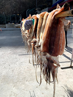
Squid drying in the sun.
More squid drying on poles.
We explored a little walking path that hugs the land along the sea.
 Because the island was formed from volcanic rocks, there are many caves and tunnels.
 Because the island was formed from volcanic rocks, there are many caves and tunnels.
The streets are so tiny and the yards are even tinier. But they make good use of their little spot they call home.
We had a nice view from the roof of our pension. This is facing east, out to the port.
Zeke is looking west, up into the mountains.After some exploring on our own, we walked with our tour group straight from our hotel room up the hill to Haedosa Temple.
Up we continued,to the Dodong Mineral Spring Park. The water is high in iron and considered medicinal. It tasted absolutely disgusting.
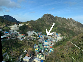
Not much farther up the mountain was the Dokdo Observatory Cable Car. You can see our pension from the cable ride.
Not much farther up the mountain was the Dokdo Observatory Cable Car. You can see our pension from the cable ride.
Once at the top we had a gorgeous view the town of Dodong and the Dodonghang Port where our ferry docked. Ulleungdo Island boasts they are 'lacking three and have plenty of 5.' They claim there are no snakes, criminals, or pollution. What they do haveplenty of is juniper trees, wind, beautiful women, water and rocks.
On clear days, which we had, you can just barely see Dokdo Island. Makes sense, as the name is Dokdo Observatory. I thought it was poppycock that they could see the tiny little dark spots on the horizon because I couldn't see with my naked eye, but when I zoomed in really close on the picture I found it!
Near the entry to the cable cars is the Dokdo Museum.There was a lot of info to read and I was being rushed by those who do not care to read about any history, let alone Korean history. But here is a document that is dated back to 1281.
The next day our group went on a bus tour of the island.
Ulluengdo is roughly 10 miles wide by almost 10 miles long. There are about 9 little villages which total around 10,000 residents. We started our tour on the south east side in the district called Ulleung-eup. A lot of the road around the island is sandwiched between the base of cliffs and the ocean, creating one of the most scenic rides.
There are several tunnels where the road goes through the mountain like in the middle of this picture.
They made pretty windows in the tunnels so you can look out.
A few weeks ago there was not one, but two major 'typoons' that headed straight over the southern part of South Korea. Sacheon was supposed to be directly in the eye of both, but we were fortunate enough that they both went east of us. Ulleundo was not that lucky. A portion of the road we traveled had been damaged for a couple weeks and was reopened just the day before our tour.
There were several areas that we could see damage. This sea wall was is one of those places.
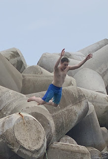
These man-made tripod things are used everywhere along ports and coasts here in Korea. They do not appear very large, but they are. Look how little Zeke looks sitting on one of them. Apparently one of the typoons carried some of them on the road. I have no idea how heavy they are, but I do know that that was some strong water!
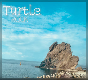
The locals like to name many of the big rocks jutting up along the coast in the waters. Turtle Rock was one of our first stops.
It looks big, but you can get an idea of just how huge it is when you see Abe and the kids at the bottom right of the picture, just below the turtle head.
A tiny tidal pool on the rocks was home to several cool sea anemones. Here are some of those hexagonal volcanic rocks like we saw on Jeju Island.
Tourism is the biggest industry on Ulleungdo. The two biggest local money makers are pumpkins and squid, hence the two mascots. Haehorang is the leaf-caped pumpkin and Oggidongyi is the squid. We purchased some pumpkin-filled and squid-filled chocolates for friends. They said they were both disgusting, but the squid ones actually tasted better.
Our bus tour took us off the shoreline and winded up through the mountain. We passed one of the two gas stations on the island and the only round-about before landing at a pumpkin stop.
Pumpkin jelly, pumpkin tea, pumpkin candy, pumpkin drinks.
This observation point views three rocks. Our guide didn't want to give us details about the origin of the name 'Old Man Peak' because we had kids in our midst, but he said we could use our imagination.You can see why Elephant Rock got its name. Our guide suggested the elephant dropped a turd behind it. DanFam5 laughed about 'chocolate chocolate' from our elephant bathing days in Thailand.For all of you geology fans, Daepunggam Cliff is composed of fancy words for rocks, like trachyte and fractured columnar joints.We continued along the northeast side to the Buk-myeon area where the Cheonbuhang Lighthouse guides the boats. Here are some of those hexagonal volcanic rocks like we saw on Jeju Island.
This is also the area of the Cheonbu Underwater Observatory.
This free observatory is located 6m below water. As you descend the stairs it gets colder and then it opens to a circular room full of windows to view the fish. They hang food containers to attract the fish for people to view.
As we were walking the bridge to enter, we saw a humongous jellyfish. We searched for it while we were underwater but couldn't find it. When we emerged to the top we found it again, but on the other side of the observatory. It was a monster!Next up was Samseonam Rocks. The folklore of Samseonam changes slightly depending on who you hear it from. The big idea is that three sisters/angels/fairies used to love to come down to earth because Ulleungdo was so beautiful. The Great Jade Emperor was not happy about it because they neglected their heavenly duties, so they were left on earth as these big rocks. I even read that the youngest dawdled behind so she has no hair, or trees, on top like the other two.
The three rocks actually have individual names: Ilseon, Iseon, and Samseon. Scientists say that the rock stacks are composed of trachyte and were initially attached to the big island but erosion over a very long period of time resulted in the three separating from not only the shore but each other as well.
This is one of the neat little 'windows' that line the road.
From the Three Angels you can turn around and see the Seomnok-Gwaneumdo Walking Footbridge.

The suspension bridge is the only way to access the island, so once you get across, Gwaneumdo has a quiet calm to it. There is a trail that goes around the top so you get the most beautiful views from the cliffs.
There are the Angel Rocks.
This is Jukdo Island. Apparently there is a cool bamboo forest there, but we did not have time to make it to that island. It is only accesable by ferry.
This is Jukdo Island. Apparently there is a cool bamboo forest there, but we did not have time to make it to that island. It is only accesable by ferry.
The bridge was erected in 2012 and it is the only access to little island. So besides for a few wooded paths created, it is just natural vegetation.To the right are the Samseon Rocks, and to the left in the middle is the big archway above the road that I posted a few pictures above.
We spent a few minutes taking in the beauty from the bridge.
Eli and I raced down. He took the elevator and I ran the stairs. He won.

Eli and I raced down. He took the elevator and I ran the stairs. He won.
We backtracked a little and went to the Nari Basin, on the north central part. The island of Ulleungdo is an extinct volcano, and the caldera, the collapsed mouth, is the Nari Basin.

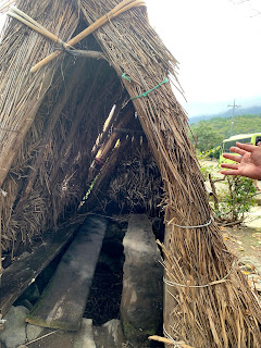
This shingled house was built in the 1940s. The shingles are held down by rocks to prevent them from being blown away by strong winds.
This is the hwajangsil.
I'm guessing you figured out that means bathroom.
I'm guessing you figured out that means bathroom.
Currently there are a variety of sizes when it comes to Korean people. I thought I would be the proper size for once, but I am still on the short side. That being said, it is only in the past few generations that they have gotten taller. The baby boomer generation is definitely small, as you can tell by the size of this house ceiling.
The smallest room had its own firebox to heat it.
This room says love room. Haha! Instead of master bedroom, I'm going to start calling my room the love room.😍
Two rooms had underfloor heating with flues connected to the kitchen.
The house had three rooms a straight line, each with log-frame walls formed by stacked logs and mud. The entire house is surrounded by udegi, which is outer walls installed under the eaves to protect the house against extreme snow, rain and wind. This sign above the door says small room.This room says love room. Haha! Instead of master bedroom, I'm going to start calling my room the love room.😍
The tour was done at this point, and we then tried to get a taxi to the Bongrae Waterfall and wind cave. It is not easy because there is not much English spoken here. The pressure was on because a family on the tour with us asked if they could follow us because they spoke Vietnamese with a little English. We ended up putting 4 of us in one taxi and Abe rode in the other taxi with them. Luckily, the taxi dropped us off where we were wanting to go. Victory!
On the hike up to the waterfall we passed a wind cave. Wind caves maintain nearly constant temperatures throughout the year. There's some science behind it about heat transfer and stuff, but there was a little hole in the wall that felt like an air conditioner blowing cool air out.
After a quick cool down from the cave we continued our hike up to the waterfall.
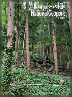
The trek up to the falls is through the forest.
There are a couple little falls along the way, too.
 At this point none of my kids were happy with me. Eli just stopped going up and decided it would not be worth it. Zeke and Daisy did not think it would be worth it but were going up any way because I was determined to get to the falls.
 We finally made it!
The trek up to the falls is through the forest.
There are a couple little falls along the way, too.
 At this point none of my kids were happy with me. Eli just stopped going up and decided it would not be worth it. Zeke and Daisy did not think it would be worth it but were going up any way because I was determined to get to the falls.
 We finally made it!
Bongrae Waterfall is composed of three steps of specific rock names that we don't really care about. It is 30m high and discharges 3,000 tons of water a day. The water is used as drinking water for the southern part of the island.
No one would pose with me, so here I am in front of this beautiful waterfall all by myself.
No one would pose with me, so here I am in front of this beautiful waterfall all by myself.
After a long day with lots of walking, the children were not having any of the traditional Korean buffet offered at the hotel that was included in our tour. I took them to the local Lotteria for hamburgers and fries.
When I woke up super early to use the restroom, I caught a beautiful sunrise from our pension window.
I didn't get the kids up that early, but we did head down to the fish market in the morning. The boats go out all night to catch squid and come in when the daylight arrives.
The boats are lined with lights so they can see what they're doing at night.
The amount of squid that is brought in daily is mind boggling! Apparently the squid economy has decreased by about 30% in the last decade so there used to be even more!Those are piles of squid all over the floor.
 We came across a pile of squid eyes that had been plucked out. Ew.
 We came across a pile of squid eyes that had been plucked out. Ew.
Once you get away from the area that they are cleaning them (or whatever it's called that they are doing), you see squid everywhere, drying in the sun.
When you're out exploring, some days you get things right, and some days you don't. This particular day our taxi drop was not as accurate as the waterfall drop. We did a bit of wondering in search of Pebble Beach, with no luck.
Nothing a quick change of plans couldn't fix.
Starting right off Chotdaebawi Rock in Jeodong Port is the Haengnam Coastal Walk.
The Dodong Lighthouse up on the cliff is the halfway point between Jeodong and Dodong.
The trail is absolutely gorgeous. Waves splash up on the shore, unique rock formations peek out from the cliffs, and caves hide among in the rocks.

We were crossing one of the Rainbow Bridges and we could see the spiral staircase in front of us. Things were finally going our way.
Until suddenly when they weren't. The trail was washed away because, typoon.
We had planned to walk the scenic route back to our town. At that point we were pros at hailing a taxi. We made it back in time for our next group excursion.We boarded another ferry headed 87 km southeast for Dokdo Island.

Dokdo, sometimes called Liancourt Rocks, consists of two main islands, Dongdo and Seodo, plus 89 surrounding islets. In total they span a little over 45 acres, but it's rocky, cliffy terrain.
Dokdo brings out all the patriotic feels for the Koreans.
The island is the center of a political dispute between Korea and Japan that has been going on for 300 years. It's just a couple islands that are not even very large size-wise. However, the islands are rich with minerals and teeming with fish. More importantly, the island is a perfect military stronghold in the East Sea. This is one thing the Koreans have kept from World War II and it's very important to them and their heritage.
As soon as our boat got close enough to slow down and we could go out on the deck to view the islands, all holds were barred. The Korean paraphernalia was out and the flags were flyin'.
When in Rome...or Dokdo.
Normally the ferry will dock and visitors can walk around, but, typoon. So we just sailed around it.
Right now there is only one resident on Dokdo Island in a single room house and that's exactly how the government want to keep it. She is an 81 year old widow. There are roughly 40 police officers and lighthouse maintenance workers who temporarily stay there for security. The guards were waving at us from the house on the left, but you can't see them in the picture.
That night we fed the kids BHC Chicken and Abe and I went on a date. Ulleungdo is famous for their 'medicinal beef.' It was good, but I'm not sure I got any medicinal benefits from it. It was, however, nice to have a date night.Korean BBQ requires you to cook the meat at the table yourself. Usually lettuce leaves are provided to wrap the meat in, and there are about a thousand side dishes.
Our last morning I joined Abe early in the day to take a hike to the Dodong Lighthouse. There was a 2000 year old tree along the way that I wanted to see. We were doing great until we weren't. The trail was closed, because, typoon. We didn't get to see the lighthouse nor the 2000 year old tree.
The tour had time set aside to jump off a bridge, but, typoon. When that got cancelled Daisy set a goal to swim anyway. So we took one more shot at Pebble Beach.[Sept. 29-Oct. 2]
 We were doing great until we weren't. The trail was closed, because, typoon. We didn't get to see the lighthouse nor the 2000 year old tree.
The tour had time set aside to jump off a bridge, but, typoon. When that got cancelled Daisy set a goal to swim anyway. So we took one more shot at Pebble Beach.
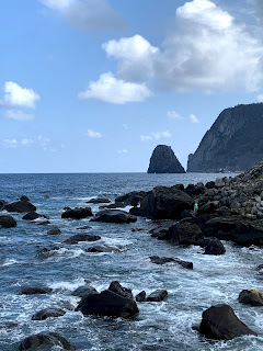
It may be called Pebble Beach, but Big Rock Beach would be a better name. The water here is crystal clear, but the beaches do not consist of soft sand. Plus the waves were coming in pretty strong so it was hard to navigate the shore.
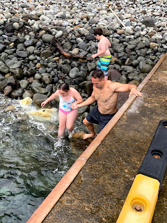
I don't do cold. I especially don't do cold water. But I decided I wasn't going to be the only DanFam5 member to not swim in the East Sea. Zeke and I went in together.



















No comments:
Post a Comment